Absolute Online Real Estate Auction
Bidding begins closing Wednesday, March 11th at 7:00PM
Ohio, Marshall, Brooke, and Hancock Counties
19 Tracts – Developable Lots in Weirton, 55 Acres in Proctor, Lots, & Houses
SELLING TO THE HIGHEST BIDDERS
MARSHALL COUNTY
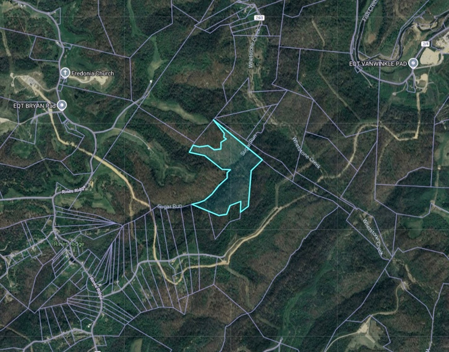
Subject #1: 55.34 +/- Acres off Rines Ridge Rd Proctor, WV
55.34 +/- Acres (as assessed)
Potential Timber
Surface Rights Only
ACCESS UNKNOWN – BUYER BEWARE
Up Sugar Run – Approx. GPS Coordinates 39.771324, -80.749134
Closest Physical Address 4680 Rines Ridge Rd Proctor, WV
Marshall County, Franklin District (05), Map 16, Parcel 17
Legal Description: 55.34 WHETSTONE LESS O&G
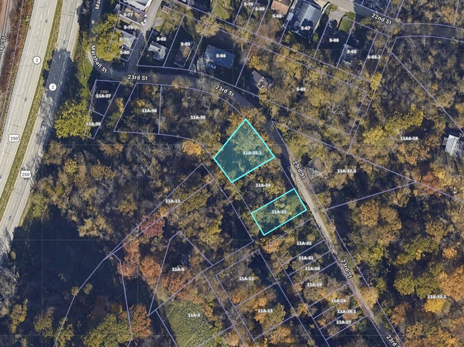
Subject #2: 0.30 +/- Acres on 23rd St McMechen, WV
Two Parcels totaling 0.30 +/- Acres (as assessed)
0.11 +/- Acres and 0.19 +/- Acres
Surrounding Properties with Public Utilities
Closest Physical Address 9 23rd St McMechen, WV
Marshall County, Union District (13), Map 11A, Parcel 33
Legal Description: LOTS 107-108 RIV IMP CO & O&G
Marshall County, Union District (13), Map 11A, Parcel 35.1
Legal Description: LOTS 101-102-103 HOSSMAN SD RIVERVIEW & O&G
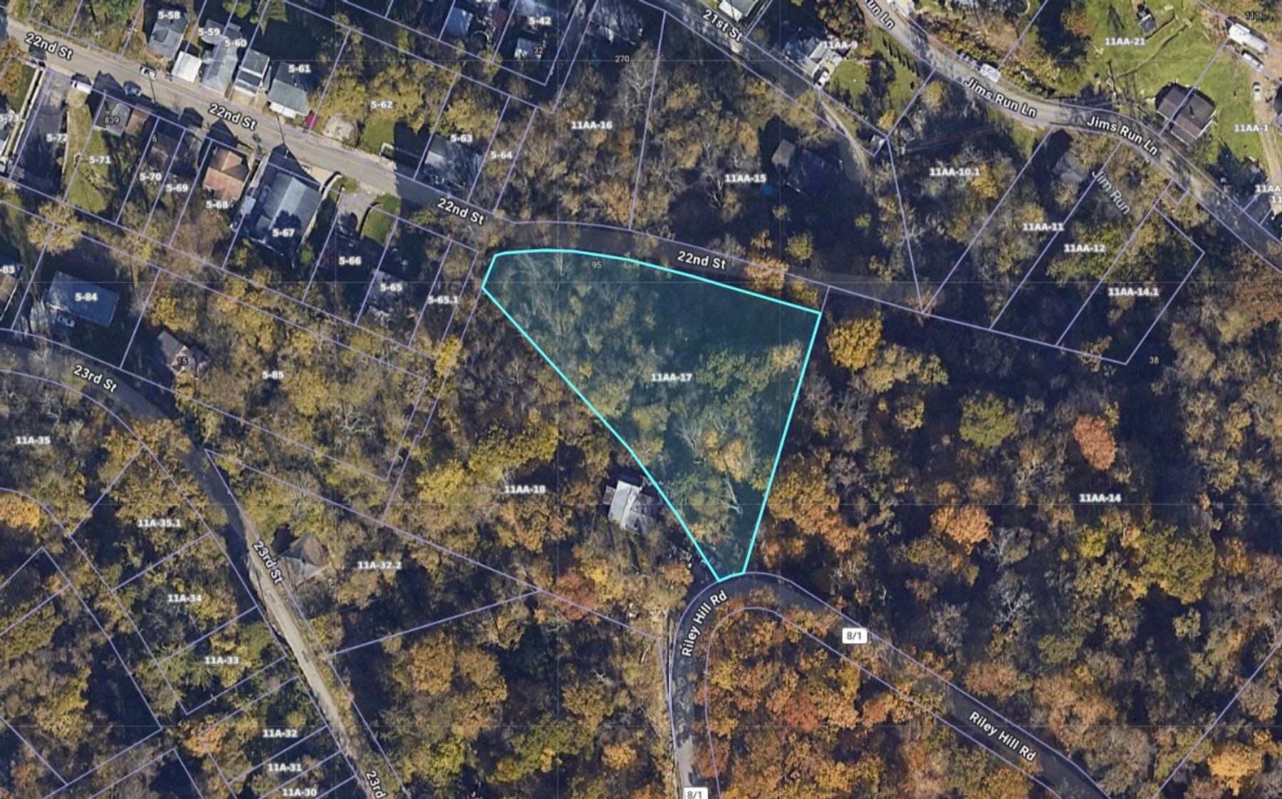
Subject #3: 1.25 +/- Acres on Reilly Hill Rd Glen Dale, WV
1.25 +- Acres (as assessed)
Closest Physical Address 36 Reilly Hill Rd Glen Dale, WV
Surrounding Properties with Public Water, Septic, Gas
Marshall County, Union District (13), Map 11AA, Parcel 17
Legal Description: 1.25 & PARCEL RIV ROAD HILL
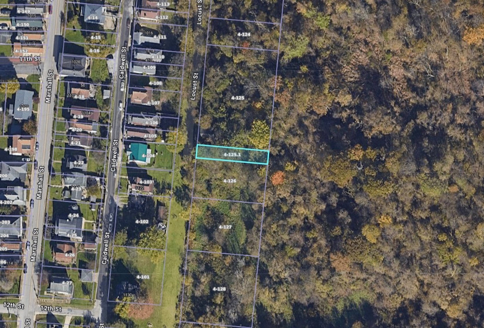
Subject #4: 0.06 +/- Acres on Locust St McMechen, WV
0.06 +/- Acres (as assessed)
Marshall County, McMechen Corp (08), Map 4, Parcel 125.1
Legal Description: LOT 18 JL MCM 1ST ADD
OHIO COUNTY
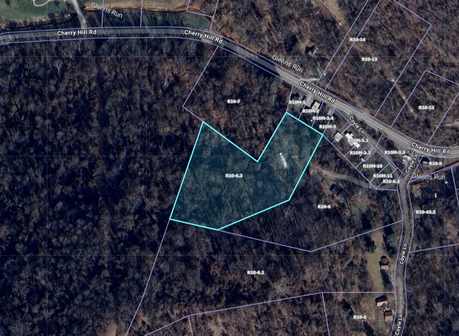
Subject #5: 3.44 +/- Acres on Coyle Ln Wheeling, WV
3.44 +/- Acres (as assessed)
72 Coyle Ln Wheeling, WV
Off Cherry Hill Rd Wheeling, WV
Public Water and Gas Available
No Title Ever for Trailer
Ohio County, Richland District (04), Map R10, Parcel 6.3
Legal Description: 3.444 ACRES GLENNS RUN S-T-S 2021
HANCOCK COUNTY
Subject #6: 0.25 +/- Acres on Brent Heights Dr Chester, WV
0.25 +/- Acres (as assessed)
Corner Lot
Surrounding Properties with Public Water, Septic
Closest Physical Address 216 Brent Heights Dr Chester, WV
Hancock County, Grant District (04), Map G15L, Parcel 9
Legal Description: .250 ACRES CLAY BRENT HTS (LOT 22)
Subject #7: 0.44 +/- Acres on Swearingen Rd Weirton, WV
0.44 +/- Acres (as assessed)
Closest Physical Address 185 Swearingen Rd Weirton, WV
Surrounding properties with Public Water, Public Sewer
Hancock County, Butler District (01), Map B35C, Parcel 51
Legal Description: 5 REVISED LAUREL HILLS
Subject #8: 0.14 +/- Acres on Cleveland Ave Weirton, WV
0.14 +/- Acres (as assessed)
Potential Building Location
Closest Physical Address 169 Cleveland Ave Weirton, WV
Surrounding properties with Public Utilities
Hancock County, Weirton Corp (06), Map W34R, Parcel 113
Legal Description: BLK H 4 WEIRCREST REV PLAT (LESS MINERALS)
Subject #9: 412 Jefferson St Newell, WV
0.17 +/- Acres (as assessed)
3 Bed, 3 Bath, 1,624 +/- Sqft
Fixer Upper Home
Two parcels totaling 0.17 +/- Acres
Public Utilities
Hancock County, Grant District (04), Map G2R, Parcel 237
Legal Description: 487 JEFF ST LESS MINERALS
Hancock County, Grant District (04), Map G2R, Parcel 238
Legal Description: 488 30X110 JEFF ST LESS MINERALS
Subject #10: 0.25 +/- Acres on Barbour Dr Weirton, WV
0.25 +/- Acres (as assessed)
Closest Physical Address 62 Barbour Dr Weirton, WV
Off Kings Creek Rd
Surrounding Properties with Public Utilities
Hancock County, Bulter District (01), Map B39M, Parcel 9
Legal Description: 75X142 (PROP SUB CHATEAU VILLA GE 2) LOT 53
Subject #11: 1.13 +/- Acres on North 12th St Weirton, WV
1.139 +/- Acres (as assessed)
Closest Physical Address 301 North 12th St Weirton, WV
351 N 12th St Weirton, WV
Public Utilities Available
Hancock County, Weirton Corp District (06), Map W39K, Parcel 2
Legal Description: 1.139 ACRES K C
Subject #12: 0.75 +/- Acres on Fairview Rd Chester, WV
0.75 +/- Acres (as assessed)
Closest Physical Address 477 Fairview Rd Chester, WV
Public Utilities Available
Hancock County, Grant District (04), Map G7E, Parcel 20
Legal Description: .750 ACRES CUNNINGHAM RUN
BROOKE COUNTY
Subject #13: 0.09 +/- Acres on Worthington Ln Colliers, WV
0.09 +/- Acres (as assessed)
Approximate GPS Coordinates 40.386091, -80.567935
Next to Panhandle Trail
Off Harmon Creek Rd Colliers, WV
Brooke County, Cross Creek District (04), Map CC3, Parcel 37
Legal Description: .09 AC HARMONS CREEK
Subject #14: 1.19 +/- Acres off Highland St Follansbee, WV
1.19 +/- Acres (as assessed)
Three Parcels Totaling 1.19 +/- Acres
Non-Contiguous
Closest Physical Address 770 Highland St Follansbee, WV
Brooke County, Follansbee Corp (05), Map F14M, Parcel 173
Legal Description: L 11-12 6 TH ADD
Brooke County, Follansbee Corp (05), Map F14M, Parcel 223
Legal Description: LOTS 41-42-43-44-45 6TH ADD
Brooke County, Follansbee Corp (05), Map F14M, Parcel 224
Legal Description: L 46-47-48-49 6TH ADD
Subject #15: 0.54 +/- Acres on Buffalo Rd Wellsburg, WV
0.54 +/- Acres (as assessed)
Closest Physical Address 44 Buffalo Rd Wellsburg, WV
Surrounding properties with Public Utilities
Brooke County, Buffalo District (03), Map B27K, Parcel 70
Legal Description: L 118 & L 119 CHAPMAN HGTS CHAPMAN HGTS-LAND M MANI BRK 3,201
Subject #16: 0.18 +/- Acres on Highland St Follansbee, WV
0.18 +/- Acres (as assessed)
Two Parcels totaling 0.18 +/- Acres
Surrounding properties with Public Utilities
Closest Physical Address 1062 Highland St Follansbee, WV
Brooke County, Follansbee Corp (05), Map F14H, Parcel 292
Legal Description: L 48 5TH ADD
Brooke County, Follansbee Corp, (05), Map F14H, Parcel 293
Legal Description: LOT 47 5TH ADDITION
Subject #17: 0.10 +/- Acres on Spruce St Follansbee, WV
0.10 +/- Acres (as assessed)
Closest Physical Address 202 Spruce St Follansbeen, WV
Surrounding properties with Public Utilities
Brooke County, Cross Creek District (04), Map C14S, Parcel 205
Legal Description: PT LOT 71 SPRINGDALE
Subject #18: 0.62 +/- Acres on Loretta Ave Follansbee, WV
0.62 +/- Acres (as assessed)
Closest Physical Address 156 Loretta Ave Follansbee, WV
Surrounding properties with Public Water, Septic
Potential Building Location
Brooke County, Cross Creek (04), Map C11K, Parcel 46
Legal Description: .62 AC PT LOT 4 F & E RD
Subject #19: 0.54 +/- Acres on May Rd Follansbee, WV
0.54 +/- Acres (as assessed)
Two Parcels totaling 0.54 +/- Acres
Trailer with NO TITLE
Public Utilities Available
Closest Physical Address 400 May Rd Follansbee, WV
Brooke County, Cross Creek District (04), Map C14M, Parcel 26
Legal Description: LOT 369 SPRINGDALE N
Brooke County, Cross Creek District (04), Map C14M, Parcel 27
Legal Description: PT LOT 369 SPRINGDALE
Please read the special terms and conditions before bidding. Buyer is responsible for all closing costs, including but not limited to deed preparation, closing Deed recording services and escrow, All deed recording fees incurred pursuant to the transfer of title, along with any state and county excise tax on the privilege of transferring realty (document stamps), All outstanding real estate taxes, charges, municipal service fees or other assessments levied or assessed against the Premises (Any currently posted county real estate taxes payable at time of closing will be paid by Purchaser at closing; All other outstanding real estate taxes, charges, municipal service fees or other assessments levied or assessed against the Premises will be paid by the Buyer after the closing); Any additional optional services such as: examination of title, title insurance, surveys, loan documentation. Any such optional services are outside of the scope of services provided by Joe R. Pyle Auctions and Walters Law Office.
Disclaimers by Seller:
BUYER BEWARE PROPERTY: Purchaser acknowledges that seller acquired title to the property through tax sale, holds the property for resale, not for investment, and has not operated the property. Said tax sale may still be within the statute of limitations, and may be overturned by potential future lawsuits causing loss of title to the property for any current or future owners.
IT IS UNDERSTOOD AND AGREED THAT SELLER HAS NOT AT ANY TIME MADE AND IS NOT NOW MAKING, AND IT SPECIFICALLY DISCLAIMS, ANY WARRANTIES OR REPRESENTATIONS OF ANY KIND OR CHARACTER, EXPRESS OR IMPLIED, WITH RESPECT TO THE PROPERTY, INCLUDING, BUT NOT LIMITED TO, WARRANTIES OR REPRESENTATIONS AS TO (I) MATTERS OF TITLE, (II) ENVIRONMENTAL MATTERS RELATING TO THE PROPERTY OR ANY PORTION THEREOF, INCLUDING, WITHOUT LIMITATION, THE PRESENCE OF HAZARDOUS MATERIALS IN, ON, UNDER OR IN THE VICINITY OF THE PROPERTY, (III) GEOLOGICAL CONDITIONS, INCLUDING, WITHOUT LIMITATION, SUBSIDENCE, SUBSURFACE CONDITIONS, WATER TABLE, UNDERGROUND WATER RESERVOIRS, LIMITATIONS REGARDING THE WITHDRAWAL OF WATER, AND GEOLOGIC FAULTS AND THE RESULTING DAMAGE OF PAST AND/OR FUTURE FAULTING, (IV) WHETHER, AND TO THE EXTENT TO WHICH THE PROPERTY OR ANY PORTION THEREOF IS AFFECTED BY ANY STREAM (SURFACE OR UNDERGROUND), BODY OF WATER, WETLANDS, FLOOD PRONE AREA, FLOOD PLAIN, FLOODWAY OR SPECIAL FLOOD HAZARD, (V) DRAINAGE, (VI) SOIL CONDITIONS, INCLUDING THE EXISTENCE OF INSTABILITY, PAST SOIL REPAIRS, SOIL ADDITIONS OR CONDITIONS OF SOIL FILL, OR SUSCEPTIBILITY TO LANDSLIDES, OR THE SUFFICIENCY OF ANY UNDERSHORING, (VII) THE PRESENCE OF ENDANGERED SPECIES OR ANY ENVIRONMENTALLY SENSITIVE OR PROTECTED AREAS, (VIII) ZONING OR BUILDING ENTITLEMENTS TO WHICH THE PROPERTY OR ANY PORTION THEREOF MAY BE SUBJECT, (IX) THE AVAILABILITY OF ANY UTILITIES TO THE PROPERTY OR ANY PORTION THEREOF INCLUDING, WITHOUT LIMITATION, WATER, SEWAGE, GAS AND ELECTRIC, (X) USAGES OF ADJOINING PROPERTY, (XI) ACCESS TO THE PROPERTY OR ANY PORTION THEREOF, (XII) THE VALUE, COMPLIANCE WITH THE PLANS AND SPECIFICATIONS, SIZE, LOCATION, AGE, USE, DESIGN, QUALITY, DESCRIPTION, SUITABILITY, STRUCTURAL INTEGRITY, OPERATION, TITLE TO, OR PHYSICAL OR FINANCIAL CONDITION OF THE PROPERTY OR ANY PORTION THEREOF, OR ANY INCOME, EXPENSES, CHARGES, LIENS, ENCUMBRANCES, RIGHTS OR CLAIMS ON OR AFFECTING OR PERTAINING TO THE PROPERTY OR ANY PART THEREOF, (XIII) THE CONDITION OR USE OF THE PROPERTY OR COMPLIANCE OF THE PROPERTY WITH ANY DECLARATIONS OR COVENANTS OF RECORD OR ANY PAST, PRESENT OR FUTURE FEDERAL, STATE OR LOCAL ORDINANCES, RULES, REGULATIONS OR LAWS, BUILDING, FIRE OR ZONING ORDINANCES, CODES OR OTHER SIMILAR LAWS, (XIV) THE EXISTENCE OR NON EXISTENCE OF UNDERGROUND STORAGE TANKS, SURFACE IMPOUNDMENTS, OR LANDFILLS, (XV) THE MERCHANTABILITY OF THE PROPERTY OR FITNESS OF THE PROPERTY FOR ANY PARTICULAR PURPOSE, (XVI) THE TRUTH, ACCURACY OR COMPLETENESS OF THE PROPERTY DOCUMENTS, (XVII) TAX CONSEQUENCES, OR (XVIII) ANY OTHER MATTER OR THING WITH RESPECT TO THE PROPERTY.
Sale "As Is, Where Is." PURCHASER ACKNOWLEDGES AND AGREES THAT UPON CLOSING, SELLER SHALL SELL AND CONVEY TO PURCHASER AND PURCHASER SHALL ACCEPT THE PROPERTY "AS IS, WHERE IS, WITH ALL FAULTS," PURCHASER HAS NOT RELIED AND WILL NOT RELY ON, AND SELLER HAS NOT MADE AND IS NOT LIABLE FOR OR BOUND BY, ANY EXPRESS OR IMPLIED WARRANTIES, GUARANTEES, STATEMENTS, REPRESENTATIONS OR INFORMATION PERTAINING TO THE PROPERTY OR RELATING THERETO MADE OR FURNISHED BY SELLER OR ANY REAL ESTATE BROKER, AGENT OR THIRD PARTY REPRESENTING OR PURPORTING TO REPRESENT SELLER, TO WHOMEVER MADE OR GIVEN, DIRECTLY OR INDIRECTLY, ORALLY OR IN WRITING. PURCHASER REPRESENTS THAT IT IS A KNOWLEDGEABLE, EXPERIENCED AND SOPHISTICATED PURCHASER OF REAL ESTATE AND THAT, EXCEPT AS EXPRESSLY SET FORTH IN THIS AGREEMENT, IT IS RELYING SOLELY ON ITS OWN EXPERTISE AND THAT OF PURCHASER'S CONSULTANTS IN PURCHASING THE PROPERTY AND SHALL MAKE AN INDEPENDENT VERIFICATION OF THE ACCURACY OF ANY DOCUMENTS AND INFORMATION PROVIDED BY SELLER. PURCHASER WILL CONDUCT SUCH INSPECTIONS AND INVESTIGATIONS OF THE PROPERTY AS PURCHASER DEEMS NECESSARY, INCLUDING, BUT NOT LIMITED TO, THE PHYSICAL AND ENVIRONMENTAL CONDITIONS THEREOF, AND SHALL RELY UPON SAME. PURCHASER ACKNOWLEDGES THAT SELLER HAS AFFORDED PURCHASER A FULL OPPORTUNITY TO CONDUCT SUCH INVESTIGATIONS OF THE PROPERTY AS PURCHASER DEEMED NECESSARY TO SATISFY ITSELF AS TO THE CONDITION OF THE PROPERTY AND THE EXISTENCE OR NON EXISTENCE OR CURATIVE ACTION TO BE TAKEN WITH RESPECT TO ANY HAZARDOUS MATERIALS ON OR DISCHARGED FROM THE PROPERTY, AND WILL RELY SOLELY UPON SAME AND NOT UPON ANY INFORMATION PROVIDED BY OR ON BEHALF OF SELLER OR ITS AGENTS OR EMPLOYEES WITH RESPECT THERETO, OTHER THAN SUCH REPRESENTATIONS, WARRANTIES AND COVENANTS OF SELLER AS ARE EXPRESSLY SET FORTH IN THIS AGREEMENT. UPON CLOSING, PURCHASER SHALL ASSUME THE RISK THAT ADVERSE MATTERS, INCLUDING, BUT NOT LIMITED TO, ADVERSE PHYSICAL OR CONSTRUCTION DEFECTS OR ADVERSE ENVIRONMENTAL, HEALTH OR SAFETY CONDITIONS, MAY NOT HAVE BEEN REVEALED BY PURCHASER'S INSPECTIONS AND INVESTIGATIONS.
ADDITIONAL TERMS:
2. ADJUSTMENTS/PAYMENT OF CLOSING COSTS:
- Seller agrees to pay for deed preparation.
- Purchaser agrees to pay for:
- Deed recording services and escrow,
- All deed recording fees incurred pursuant to the transfer of title, along with any state and county excise tax on the privilege of transferring realty (document stamps),
- All outstanding real estate taxes, charges, municipal service fees or other assessments levied or assessed against the Premises (Any currently posted county real estate taxes payable at time of closing will be paid by Purchaser at closing; All other outstanding real estate taxes, charges, municipal service fees or other assessments levied or assessed against the Premises will be paid by the Buyer after the closing);
- Any additional optional/outside services such as: examination of title, title insurance, surveys, and loan documentation. Any such optional/services may be procured by Buyer outside of this transaction and prior to closing.
3. CONDITION OF PREMISES: Purchaser accepts the Premises and the improvements thereon in their present physical condition, AS IS, WHERE IS, WITH ALL FAULTS. Seller shall not be liable for any representations or warranties respecting the physical condition, size, or characteristics of the Premises, and unless provided for in this Agreement, Seller is not bound to make any changes, add any improvements, or repair any defects in the Premises. The Premises shall be delivered to the Purchaser in substantially as good a condition as it was on the date of entering into this Agreement, except for usual wear, tear, and loss.
4. RISK OF LOSS: The risk of loss or damage to the Premises shall be borne by the Purchaser from and after the bid strikedown at the time of sale. The Seller will not deliver possession of the Premises to the Purchaser, who shall be solely responsible for obtaining possession of the Premises. Further, the Seller shall be under no duty to cause any existing tenant or person occupying the Premises to vacate said property.
10% nonrefundable down payment made day of auction with balance due at closing. No financing contingencies will be entered into the contract. Any required inspections must be completed prior to bidding. Property is being sold as is, where is with no warranty written or implied.
Announcements sale day take precedence over all advertisements published. 10% Buyers Premium will be added to determine final contract price. Name of purchaser on contract must be the name of the winning bidder or an entity which the winning bidder legally represents. No exceptions.
AGENCY DISCLOSURE: Joe R. Pyle Auction and Realty Service is acting as Auctioneer/Agent and is an agent for the seller only.
DISCLAIMER: All information regarding the description of this property is derived from sources deemed reliable but not warranted. Information is believed to be correct to the best of auctioneer/agent’s knowledge but is subject to inspection and verification by all parties relying on it. Sellers, their representatives and auctioneer/agent shall not be liable for inaccuracies, errors, or omissions.
Any references to acreage, unless otherwise noted, are derived from public record and are not warranted. Buyers are responsible for conducting their own research prior to bidding.
BUYER/BROKER INFORMATION: Commission will be paid to any properly licensed buyer's broker who registers a successful buyer according to the Broker Participation Guidelines. Broker registration forms are available on our website or from the company office. Broker must be registered 24 hours prior to Auction. Brokers/Agents are not entitled to a commission if they are the purchaser.
We don't just list your property - WE SELL IT!
JOE R. PYLE COMPLETE AUCTION & REALTY SERVICE
Joe R. Pyle, Broker
(888) 875-1599
5546 Benedum Drive Shinnston West Virginia 26431
www.joerpyleauctions.com
Charlotte Pyle WV2174
Alan Heldreth WV2224
Jordan Kiger WV2246
Bob Stewart, Jr WV825
Bob Stewart, III WV1292
Todd Short WV1649
Tia Wolski WV2351
Ethan Moore WV2354
Taylor Ramsey WV2352
Nick Dawkins WV2410
Bud Shingleton WV1956
Colton McCown WV2463
Garrett Wilkerson WV2541A
Thomas Heldreth WV2520A
John Powell WV2481A
Taylor Self WV2521A
Kevin Zakariasen WV2482A
Brooke Patterson WV2536A
Carter Walker WV2542A