
Absolute Land Auction
Saturday, September 25th at 10:00AM
Registration Will Begin at 9:30AM
Auction Held at:
Best Western Plus Louisa
Conference Center
18199 Highway 23
Louisa, KY
Over 750+/- Acres in Lawrence County KY Selling in Parcels to the Highest Bidders
Joe R Pyle Auctions is Trusted to Auction off The Estate of JD Hardin in Lawrence County Kentucky.
Mr. Hardin’s career of buying land throughout Lawrence County was known by many. Now his heirs are looking for individuals to appreciate these parcels like Mr. Hardin did. We are auctioning over 750+/- Acres in Louisa & Blaine, Kentucky. Some home sites, some timber value and some highway frontage! This is a once in a lifetime event and… They all are selling to the HIGHEST Bidders. Join us Saturday, September 25th at 10:00AM
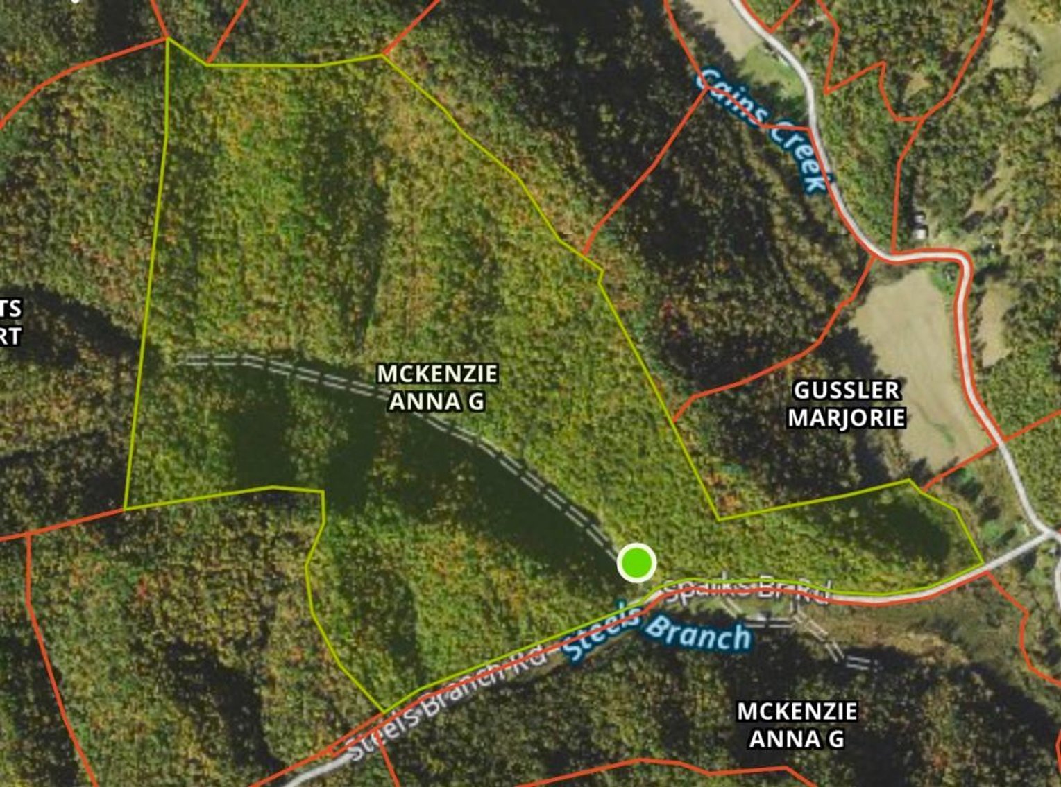
Subject One: Steels Branch Road, Blaine KY
253.541+/- Acres of Land (As Assessed)
Utilities Available Nearby
Barn on the Property, Condition Unknown
Beautiful Scenery, Mix of Wooded, Cleared, Flat & Hill Land
Pond on The Property! Beautiful Home Site
Potential for Timber VALUE!
Surface Rights Only
*This Acreage Comes from a Mapping App & Has Not Been Surveyed, Deed Description is Noted in Photos for Reference – Deed Reference is Tract #2 Deed Book 336, Page 167 & 168
GPS Coordinates: 38.05167, -82.87833
Directions: Off of KY-32, turn onto Cains Creek Road. In 2.2 Miles turn onto Steels Branch Road. Property Begins just over the bridge.
Map Number: 025-00-00-053
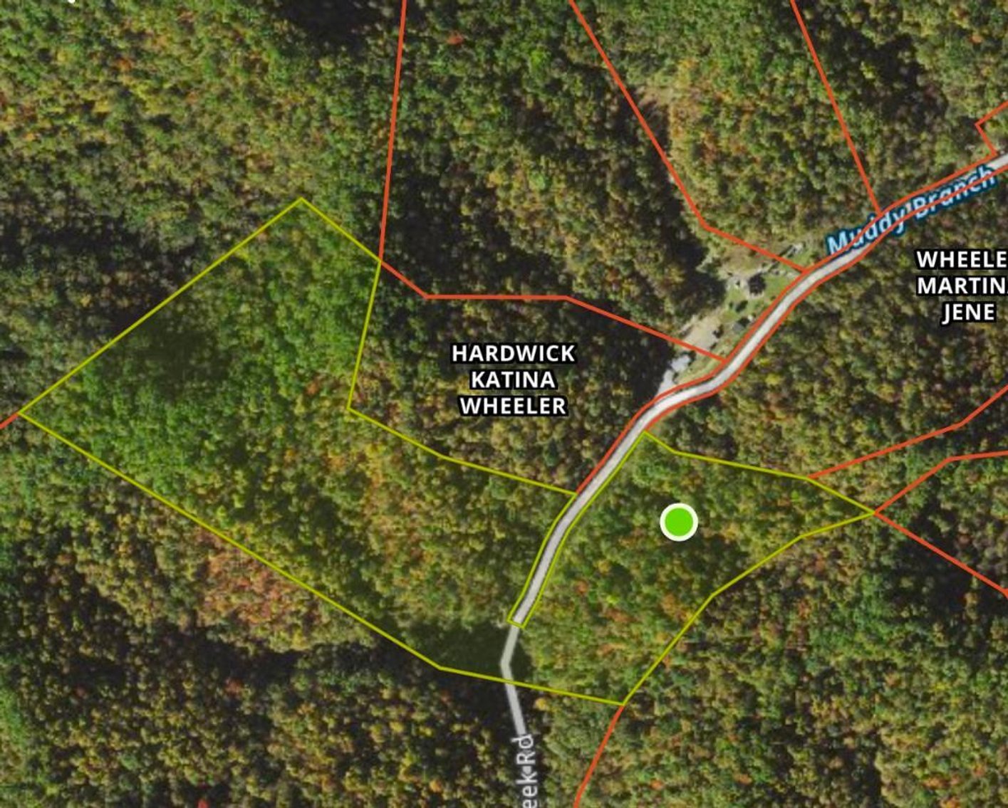
Subject Two: Muddy Branch Road, Blaine KY
34.977+/- Acres of Land (As Assessed)
Ideal Home Site w/ Privacy
Surface Rights Only – Mostly Flat Land
*This Acreage Comes from a Mapping App & Has Not Been Surveyed, Deed Description is Noted in Photos for Reference – Deed Reference is Tract #5 Deed Book 336 Page 169 & 170
GPS Coordinates: 38.01201, -82.85558
Directions: Off of KY-32 turn onto KY-201. Turn right in 0.7 Miles onto Muddy Branch Rd. Arrive at destination is 0.6 Miles. The Road Will End Prior to the Property Beginning
Map Number: 026-00-00-015
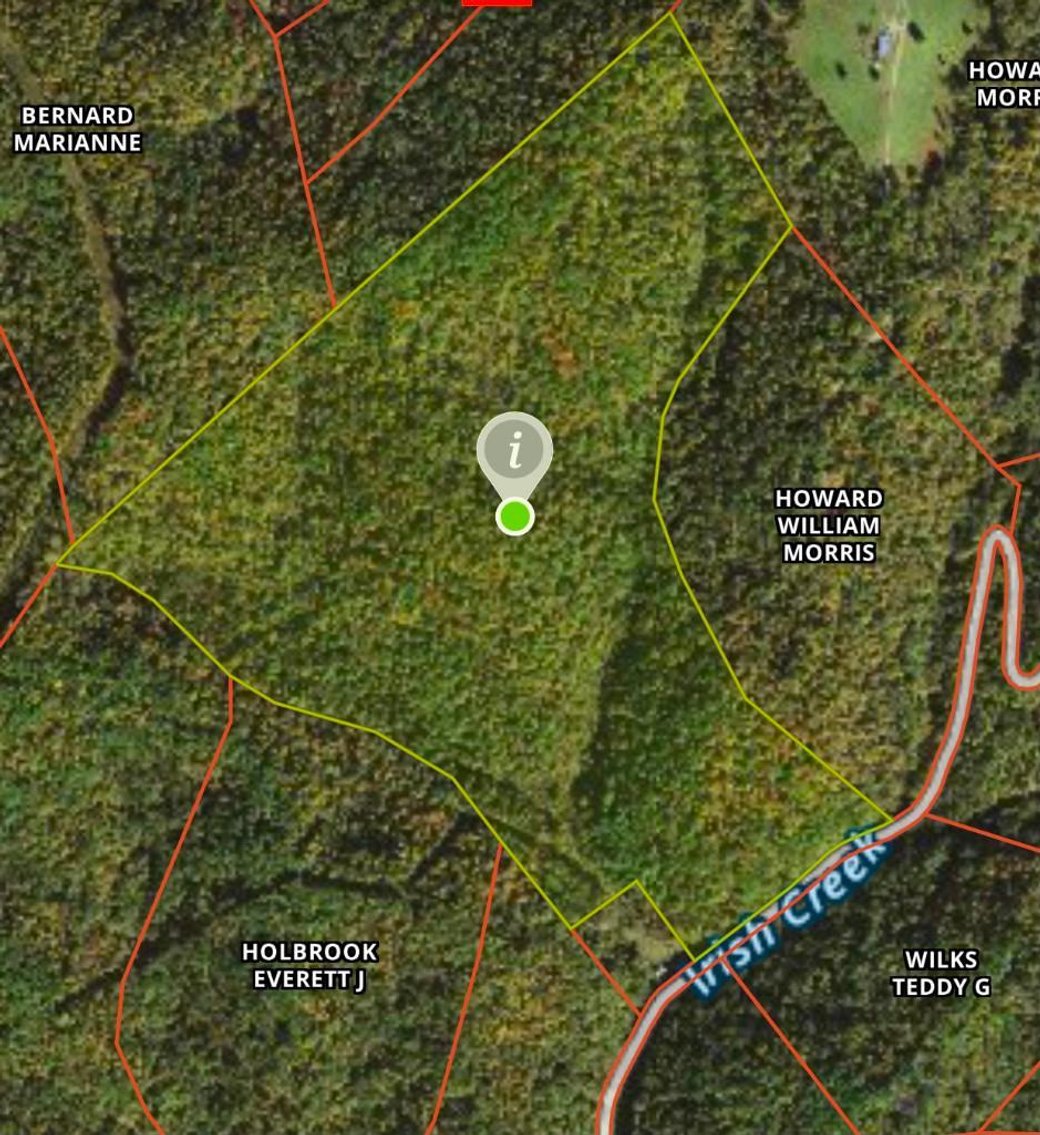
Subject Three: Irish Creek Rd – Blaine, KY
98.713+/- Acres (As Assessed)
Camping, Hunting Ground, TIMBER! Great Possibilities with this Land
*This Acreage Comes from a Mapping App & Has Not Been Surveyed, Deed Description is Noted in Photos for Reference – Deed Reference is Tract #13 of Deed Book 336 Page 174
GPS Coordinates: 38.12938, -82.82321
Directions: Off of KY-201 turn left onto Wolfpen Trail in 9.4 Miles. Then right onto Irish Creek Rd in 1.8 Miles.
Map Number: 031-00-00-027
GPS Coordinates: 38.01366, -82.78246
Map Number: 045-00-00-035
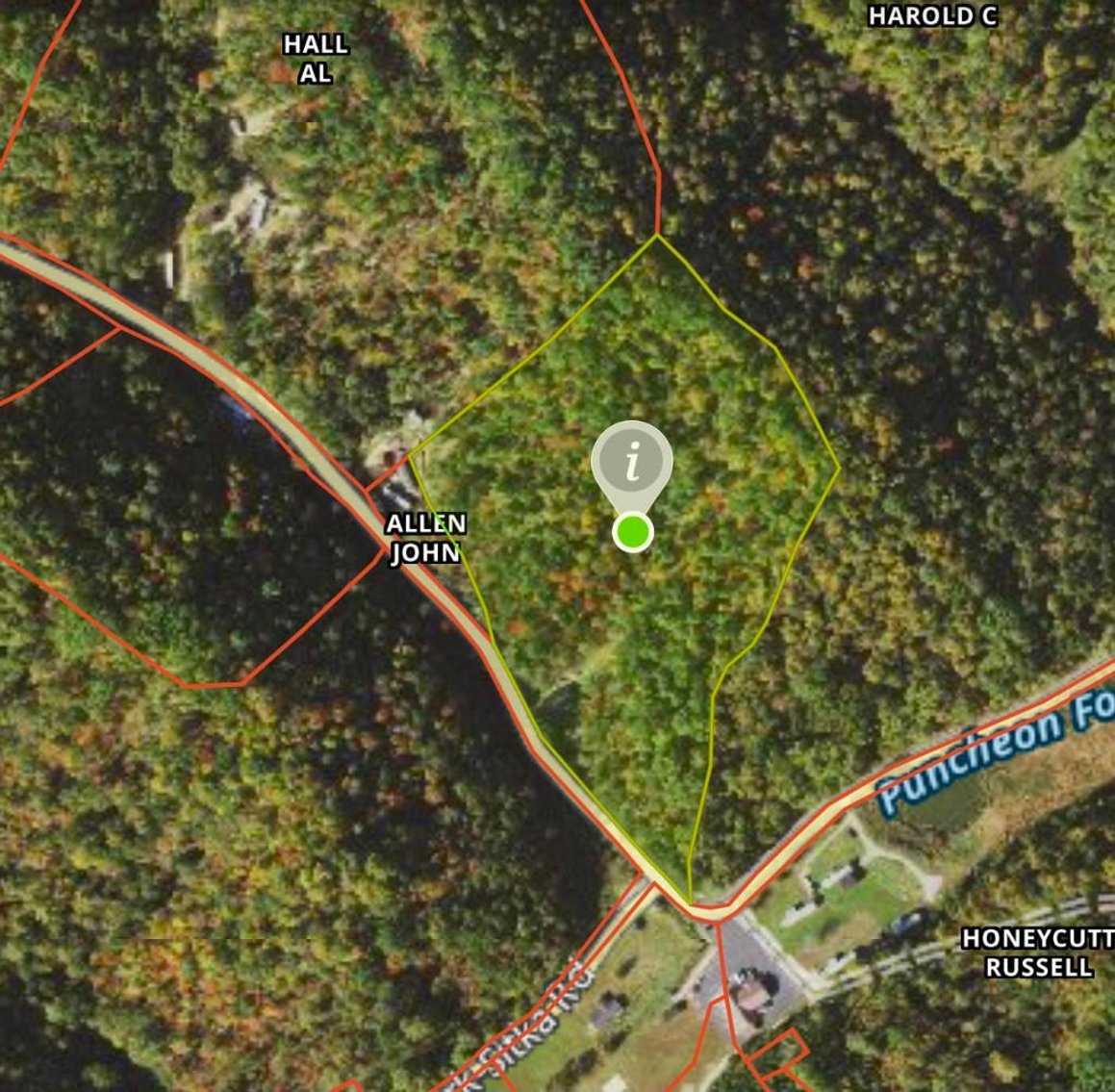
Subject Four: Ivory Road – Louisa, KY
16.332+/- Acres (As Assessed)
Condition of Homes on Premises Are Unknown
*This Acreage Comes from a Mapping App & Has Not Been Surveyed, Deed Description is Noted in Photos for Reference – Deed Reference is Deed Book 274, Page 143
GPS Coordinates: 38.04276, -82.67983
Directions: Off of KY-32, turn left onto Left Fork Little Blaine Creek Rd in 4.8 Miles. Then left onto Ivory Road in 1.5 Miles.
Map Number: 081-00-00-011
Subject Five: Highway 23 – Louisa, KY
11.919+/- Acres (As Assessed) of Highway 23 Frontage!
Some Cleared Land for Parking, Etc.
*This Acreage Comes from a Mapping App & Has Not Been Surveyed, Deed Description is Noted in Photos for Reference – Deed Reference is Tracts 10, 11 & 12 in Deed Book 336, Pages 173-174
GPS Coordinates: 38.06392, -82.63428
Directions: Put in Fairview Drive, Louisa KY in a GPS – Property sets right before Fairview Drive on the right. Cleared Property. Look for Joe Pyle Signs.
Map Number: 094-00-00-140, 095-00-00-002 & 003
Subject Six: Chapman Street, State Highway 2037 – Louisa, KY
57.818+/- Acres (As Assessed)
Incredible Piece of Property!
Near Chapman Community Park
*This Acreage has Been surveyed by P&A Engineers in Louisa KY, Deed Description is Noted in Photos for Reference – Deed Reference is Deed Book 336, Page 182
GPS Coordinates: 38.02698, -82.61542
Directions: Off of KY-2037, continue onto Chapman Street in 2 miles. In 2.2 Miles arrive at Chapman Street. Property Borders Chapman Street & Spring Branch Rd.
Map Number: 108-00-00-020.00
Subject Seven: Highway 23/Hewlet Branch Rd – Louisa, KY
19.021+/- Acres of Land (As Assessed)
HUGE Highway 23 Frontage, Heavily Traveled Highway
Some Cleared Land
Surface Rights Only
*This Acreage Comes from a Mapping App & Has Not Been Surveyed, Deed Description is Noted in Photos for Reference – Deed Reference is Deed Book 336, Page 5
GPS Coordinates: 38.16265, -82.64533 (Almost Directly Across Barn Door Feed & Tack)
Directions: Hewlet Branch Rd if off of US-23 South. Across from Barn Door Feed & Track.
Map Number: 091-00-00-036
Subject Eight: State Highway 1760 – Louisa, KY
78.708+/- Acres (As Assessed)
BEAUTIFUL LAND!
Pond On Site, Some Cleared & Wooded Land!
Ideal Private Home Site
*This Acreage Comes from a Mapping App & Has Not Been Surveyed, Deed Description is Noted in Photos for Reference – Deed Reference is Deed Book 336, Page 182
GPS Coordinates: 38.02169, -82.70888
Map Number: 069-00-00-027
Subject Nine: Big Branch Road/ Left Fork Big Branch Road – Blaine, KY
43.333+/- Acres (As Assessed)
Condition of Home on Premises, Unknown
Nice Size Property for Home, Camping, Hunting, ETC!
*This Acreage Comes from a Mapping App & Has Not Been Surveyed, Deed Description is Noted in Photos for Reference – Deed Reference is Deed Book 336, Page 182
GPS Coordinates: 38.03750, -82.78876
Directions: Off of KY-32 turn left onto Big Branch Rd. Turn left in one mile onto Left Fork Big Branch Rd.
Map Number: 045-00-00-003
Subject Ten: Rock House Branch Road, Blaine KY
86.594+/- Acres of Land (As Assessed)
Utilities Available Nearby
Great for Hunting, Potential Lumber & More!
Surface Rights Only Known
*This Acreage Comes from a Mapping App & Has Not Been Surveyed, Deed Description is Noted in Photos for Reference – Deed Reference is Tract #3 Deed Book 336 Page 169
Subject Eleven: Highway 3/Pruitt Branch Rd – Louisa, KY
11.291+/- Acres of Land (As Assessed)
Surface Rights Only
*This Acreage Comes from a Mapping App & Has Not Been Surveyed, Deed Description is Noted in Photos for Reference – Deed Reference is Tract #14 of Deed Book 336, page 175
GPS Coordinates: 37.98189, -82.53585
Map Number: 122-00-00-074
Subject Twelve: Wilbur Road (Rock House Road) – Blaine, KY
54.176+/- Acres of Land (As Assessed)
Surface Rights Only Known
Utilities Available Nearby
*This Acreage Comes from a Mapping App & Has Not Been Surveyed, Deed Description is Noted in Photos for Reference – Deed Reference is Tract #8 Deed Book 336 Page 171
GPS Coordinates: 37.96426, -82.78859
Map Number: 047-00-00-017
Sold in cooperation with Woodrow Wilson, Broker 179027
Property will be sold free and clear of all liens. Seller is conveying surface rights only with no oil, gas, coal, mineral, or other subsurface interests conveyed unless otherwise noted. 60 days given to close. Announcements sale day take precedence over all advertisements published. 10% Buyers Premium will be added to determine final contract price. Name of purchaser on contract must be the name of the winning bidder or an entity which the winning bidder legally represents. No exceptions. Real estate sold subject to owner confirmation unless otherwise noted.
AGENCY DISCLOSURE: Joe R. Pyle Auction and Realty Service is acting as Auctioneer/Agent and is an agent for the seller only.
DISCLAIMER: All information regarding the description of this property is derived from sources deemed reliable but not warranted. Information is believed to be correct to the best of auctioneer/agent’s knowledge but is subject to inspection and verification by all parties relying on it. Sellers, their representatives and auctioneer/agent shall not be liable for inaccuracies, errors, or omissions.
Any references to acreage, unless otherwise noted, are derived from public record and are not warranted. Buyers are responsible for conducting their own research prior to bidding.
BUYER/BROKER INFORMATION: Commission will be paid to any properly licensed buyer's broker who registers a successful buyer according to the Broker Participation Guidelines. Broker registration forms are available on our website or from the company office. Broker must be registered 24 hours prior to Auction. Brokers/Agents are not entitled to a commission if they are the purchaser.
JOE R. PYLE COMPLETE AUCTION & REALTY SERVICE
(888) 875-1599
5546 Benedum Drive Shinnston West Virginia 26431
www.joerpyleauctions.com
Joe R. Pyle RP3864